| Group | Key Points |
|---|---|
| 1. Maintain | • Overall structure of landscape guide, including flexibility |
| • Ability to make trade-offs with other objectives | |
| • LGFU definitions | |
| • Landscape classes | |
| • Desirable levels and milestones | |
| • Structure and composition indicators | |
| • Texture and pattern indicators | |
| • Documentation of LLPs | |
| • Dynamic Caribou Habitat Schedule | |
| • Old growth | |
| 2. Improve | • Messaging/communications |
| • Caribou direction | |
| • Especially calving and nursery habitat | |
| • Old growth direction | |
| • Red and white pine direction | |
| • Pre-industrial condition estimates | |
| • LLP direction (e.g., limits, connectivity) | |
| • Road-related direction | |
| • Consideration for other land uses | |
| • Ability to apply Indigenous knowledge | |
| • Ability to apply spatial models | |
| • Ontario’s Landscape Tool (OLT) | |
| • Effectiveness monitoring | |
| 3. Introduce | • Climate change/resiliency |
| • Indigenous Knowledge | |
| • Road-related direction | |
| • Cumulative disturbance metric | |
| • Social objectives | |
| • Spatial distribution of mature and old forest (considerations of cumulative impacts) | |
| • Time since fire based indicators | |
| • Direction for wolverine | |
| • Direction for Caribou Coastal Range and Discontinuous Distribution | |
| • Plain language (e.g., summary of direction) | |
| 4. Remove | • LLPs for moose and deer (“pick one guide”) |
| • Caribou (separate guide) | |
| • Remove prescriptive direction | |
| • Young forest | |
| • (Move away) from relying on age as an indicator of structure | |
| • Ontario’s Landscape Tool (replace with new tools) |
2 Summary of Engagement
The following sections provide a summary of the engagement efforts described in section 1. An overview of participation in the information sessions, workshops, and surveys is provided, including details about the structure of workshop activities, structure of the online survey, and a summary of feedback received.
2.1 Information Sessions
Approximately 175 people registered to attend the online information sessions, and approximately 140 of those registrants joined the live session online. There were also several requests for copies of the recording. Participation included representatives of First Nation communities and organizations, Métis communities and organizations, stakeholders, practitioners, government staff, and other interested individuals.
Themes of questions and discussion during the information session included a need to improve Indigenous consultation and engagement, inclusion of Indigenous Knowledge in the landscape guides, consideration for cumulative effects and the need for integrated land use planning, communication challenges with the technical nature of the landscape guides, and clarification of what is in scope for the review and potential revisions.
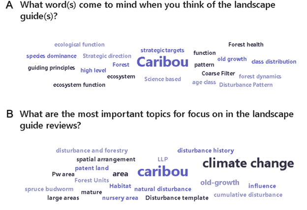
During the information sessions, there were two word clouds created in response to the following questions (Figure 2.1):
What word(s) come to mind when you think of the landscape guide(s)?
What are the most important topics for focus in the landscape guide reviews?
The two most common words used in response to these questions were “caribou” and “climate change”. The topics of “old growth”, “natural disturbance”, “cumulative effects”, and terms related to spatial distribution (e.g., spatial arrangement”) and scale (e.g., “large areas” were also included. This exercise helped to inform the creation of workshop activity 3 (see section 2.2.1.3).
The information sessions generally achieved the intent to provide general communication about the landscape guide reviews to a broad audience. Clarification about the distinction between the review and revision process was provided, and information about next steps for the review were shared. The information sessions also prepared participants to join the more technical workshops by providing background information and an overview of the workshop structure.
2.2 Workshops
Approximately 200 people participated in the landscape guide review workshops, including representatives of First Nation communities and organizations, Métis communities and organizations, stakeholders, practitioners, government staff, and other interested individuals. For the workshops that focused on the BLG, there were approximately 120 participants, and for the GLSL LG there were approximately 50 participants. For the workshops that focused on both landscape guides, there were approximately 40 participants. Some participants attended multiple workshops depending on their experience and area of interest.
Section 2.2.1 provides a detailed description of each activity in the workshop and a brief summary of results. More detailed results are provided in Appendix B. Section 2.2.2 provides a brief summary of main discussion points and themes at each workshop.
2.2.1 Workshop Activities
After reviewing the mandatory direction (i.e., standards and guidelines) in the landscape guide(s), workshop participants completed four activities: dot voting, interview matrix, specific landscape guide topics, and cue cards.
2.2.1.1 Activity 1: Dot Voting
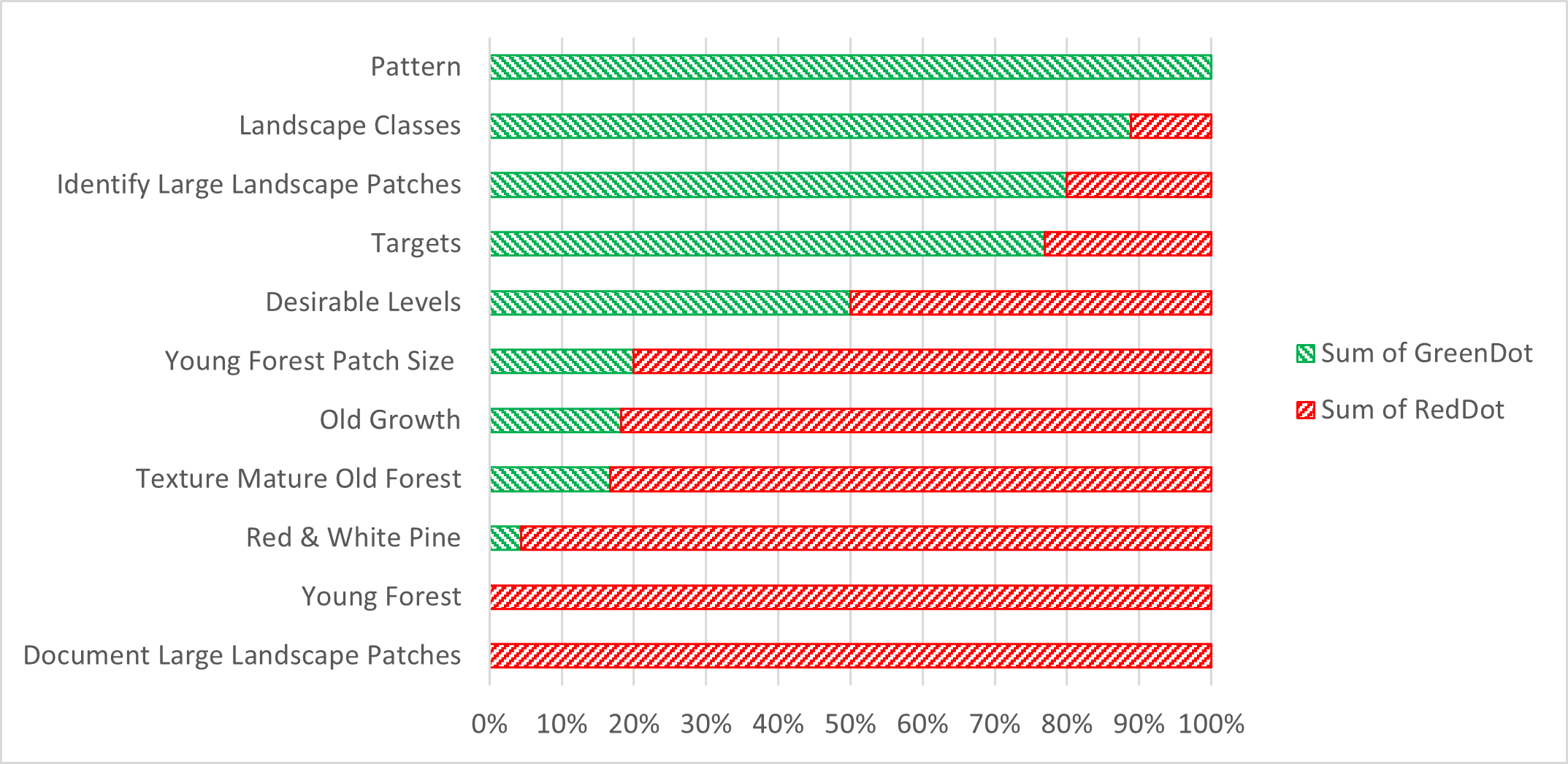
The goal of the Dot Voting activity was to receive participant input on the mandatory direction in the landscape guide. Specifically, what direction is important to maintain in the landscape guide, and what direction is a priority to consider revising. A display board with a copy of the mandatory direction from section 3 of the landscape guide was set up in the room, organized by subsections in the guide (Figure 2.2). A copy of this direction was also provided as a handout to participants, as well as six red dots and six green dots.
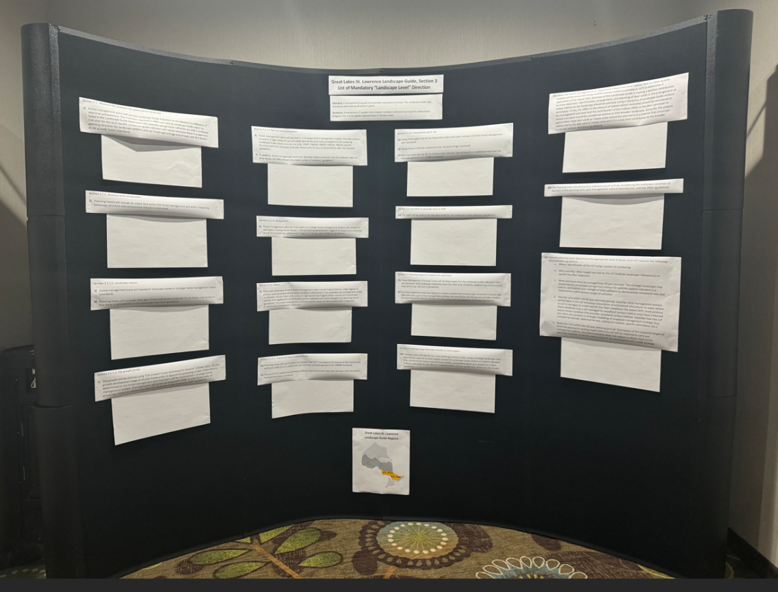
With reference to the current mandatory direction, workshop participants were asked to put a red dot on the direction or subsection(s) that they believe were the highest priority to consider revising and to put a green dot on the direction or subsection(s) that they believe were the highest priority to maintain (without revision). Participants could place as many or as few stickers on a given section as they would like to and could complete the activity any time throughout the day. The display board became a place to gather during the breaks and at the end of the day and hold informal discussions about the guide with colleagues. An example of the result of this activity is provided in Figure 2.3.
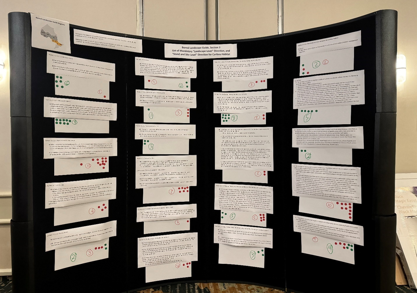
The number of dots used in this activity varied by workshop and participant. Some participants opted to use few or no dots, which is assumed to be driven by their experience in applying the guide(s). Therefore, the results should be considered general in nature, and the ability to make comparisons across workshops is limited. The context of how materials were presented and the discussion that occurred during the workshop also influenced results. For example, when the workshop presenter commented that direction related to the landscape classes received all green dots in previous sessions, it was the first workshop where red dots were placed on that section of the guide.
The results were summarized separately for workshops focused on each landscape guide. Figure 2.4 is a graph showing a summary of the average proportion of green and red dots that were placed on each subsection of the Boreal Landscape Guide. The direction for landscape classes, milestones, and large landscape patches (LLPs) generally received the highest support to be maintained without revision, while the caribou related direction, red and white pine indicators, and texture of mature and old forest indicators were identified as highest priority to be considered for revision.
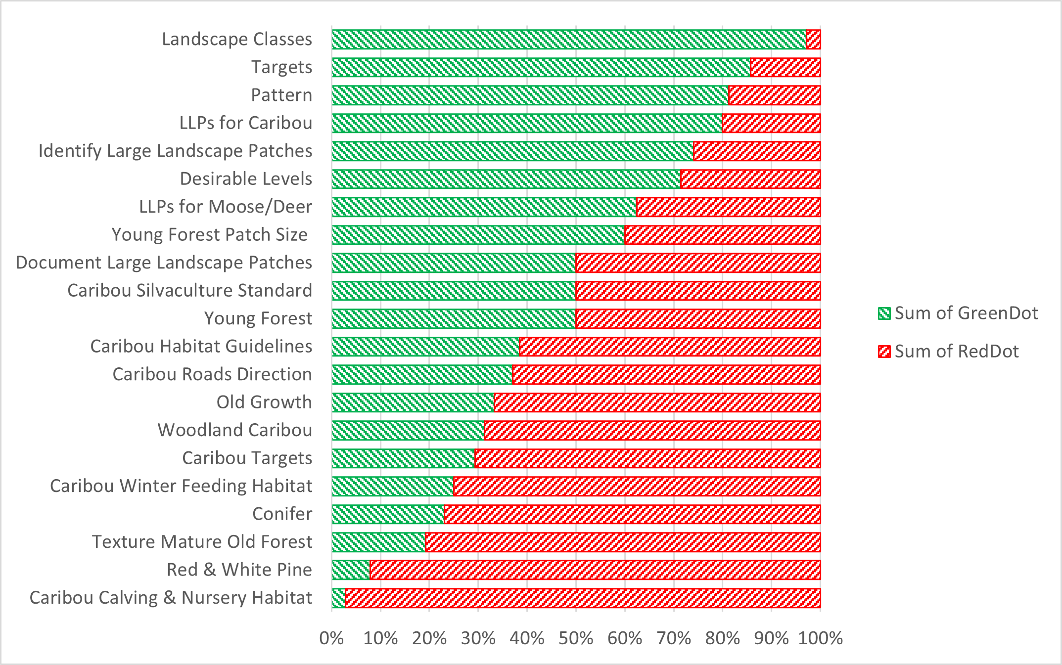
Figure 2.5 is a graph showing a summary of the average proportion of green and red dots that were placed on each subsection of the Great Lakes-St Lawrence Landscape Guide. The direction for pattern indicators and landscape classes generally received the highest support to be maintained without revision, while the young forest indicator direction and documentation of large landscape patches were identified as highest priority to be considered for revision.
2.2.1.2 Activity 2: Interview Matrix
The goal of the Interview Matrix activity was to gain a better understanding of participant experience with the landscape guides, with a focus on implementation experience. The answers to four questions were explored:
Question 1: What landscape guide direction would you want to maintain?
Question 2: What landscape guide direction would you want to improve?
Question 3: What new landscape guide direction would you want to introduce?
Question 4: What landscape guide direction would you want to remove?
Participants were divided into groups of four, and each member of the group was given a number: 1,2,3 or 4. The number assigned to the participant matches the question number they were assigned to ask.
The first part of this activity required participants to interview each other within their group of four and take notes on the responses they received to their assigned question. The interviews were one-on-one, and conducted in a series of six rounds:
Round 1: One (1) ask Two (2) and Four (4) ask Three (3)
Round 2: One (1) ask Three (3) and Four (4) ask Two (2)
Round 3: One (1) ask Four (4) and Two (2) ask Three (3)
Round 4: Three (3) ask One (1) and Two (2) ask Four (4)
Round 5: Two (2) ask One (1) and Three (3) ask Four (4)
Round 6: Four (4) ask One (1) and Three (3) ask Two (2)
After the interviews were complete, participants joined a group with everyone who was assigned the same question. This resulted in four groups that collectively discussed the feedback they heard about what direction in the guide should be (1) maintained, (2) improved (3) introduced, and (4) removed. Each group summarized the key points on chart paper, and these findings were presented to all workshop participants.
Table 2.1 provides a summary of the key points discussed in the interview matrix activity specific to the Boreal Landscape Guide.
Table 2.2 provides a summary of the key points discussed in the interview matrix activity specific to the Great Lakes-St. Lawrence Landscape Guide.
| Group | Key Points |
|---|---|
| 1. Maintain | • Overall structure of landscape guide |
| • Old growth indicators (perhaps with some changes) | |
| • Keep consistent LGFU as previously used | |
| • Landscape classes and landscape guide indicators (support annual reporting) | |
| • Inclusion of LLPs, including the flexibility in direction to apply them | |
| • Support and development of OLT | |
| 2. Improve | • Red and white pine direction |
| • Support system for tools (e.g., OLT) to apply the guide | |
| • Application of the guide through spatial modelling | |
| • Messaging/communications, simplify the guide | |
| • Elaborate on the direction related to “judicious use” of LLPs, and provide clarity on how planning teams can apply LLPs | |
| • Old growth direction (consider pro-rating), separate terms “old” and “old growth”. | |
| • Pre-industrial condition estimates | |
| • Road-related direction | |
| • Consideration for other land uses | |
| • Increase flexibility to consider the achievement of non-landscape guide objectives as a priority over landscape guide indicators | |
| 3. Introduce | • Climate change/resiliency |
| • Social objectives | |
| • Use spatial models to apply the guide | |
| • Coordinate planning across management units | |
| • Considerations for cumulative effects | |
| • More clarification of connections with the stand and site guide | |
| • Consider risk in implementation of the landscape guide | |
| • More clarification on how the landscape guide applies to highly fragmented landscapes | |
| • Make effectiveness monitoring approach clearer. | |
| 4. Remove | • Direction related to 1995 levels of red and white pine |
| • One workshop suggested the biodiversity indicators were redundant with other direction | |
| • Texture assessments, noting that it is challenging to create young forest with silviculture systems in the south |
2.2.1.3 Activity 3: Deeper Dive into Specific Landscape Guide Topics
The goal of the Deeper Dive activity was to receive participant input on more specific topics related to the landscape guides. The topics chosen for this activity were based on participant interests and informed by the word cloud activity described in section 2.1 (Figure 2). The list of potential topics to focus on in this activity included:
- Alignment with other direction and land uses
- Caribou (BLG only)
- Climate change
- Cumulative effects
- Effectiveness monitoring
- Large Landscape Patches
- Milestones (including technical note)
- Natural disturbances (types, severity, history)
- Old growth
- Red and white pine
- Science and Information Packages and Ontario’s Landscape Tool
- Silviculture Systems (GLSL LG only)
- Simulated Ranges of Natural Variation (SRNVs)
- Texture and pattern indicators
Participants were encouraged to consider Indigenous knowledge in all topics and were given the option to identify additional topics to include in the activity. Some additional topics that were included were “Landscape Classes and Forest Units” and “Biodiversity Indicators”. The latter topic amalgamated multiple topics from the original list.
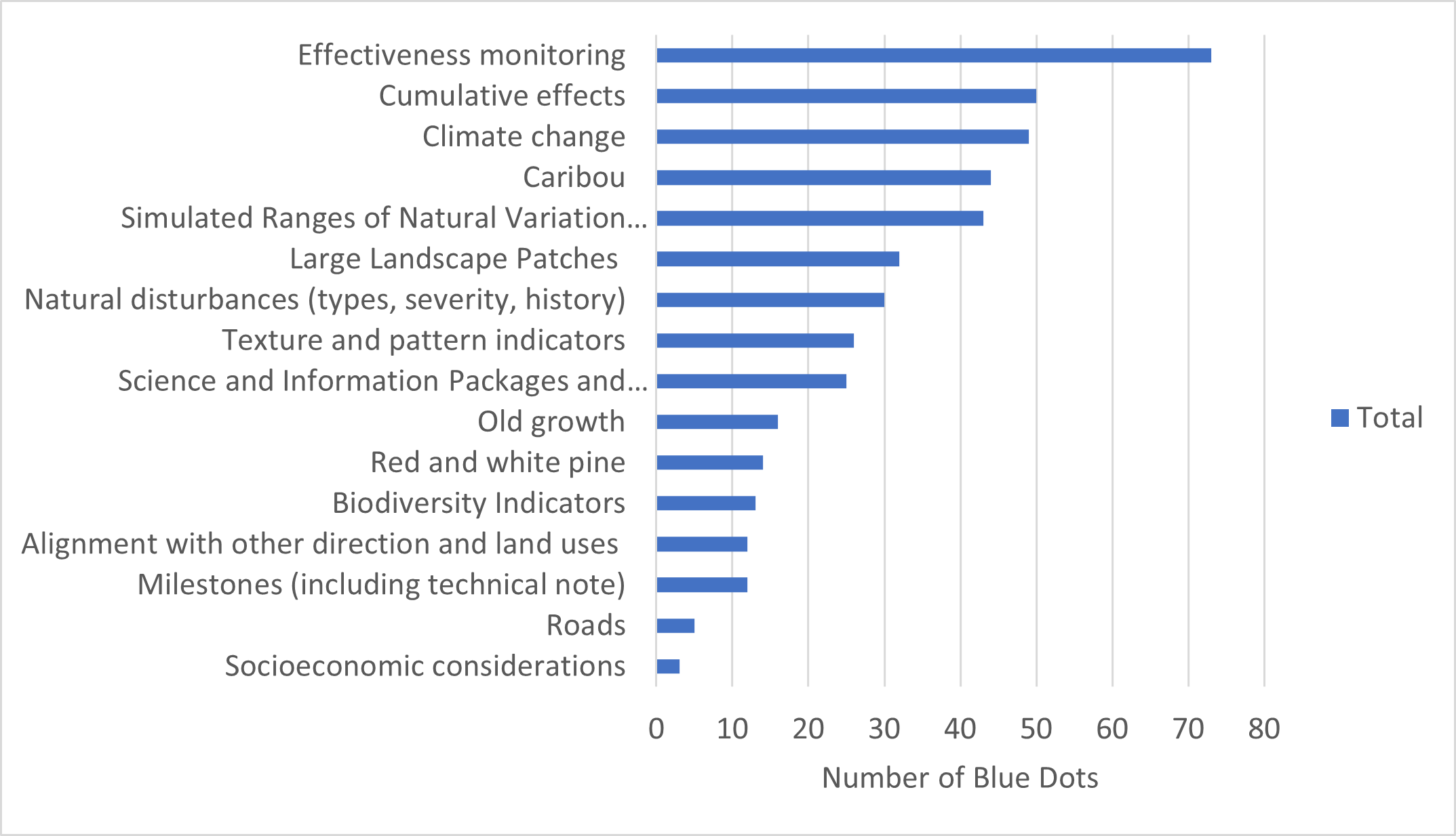
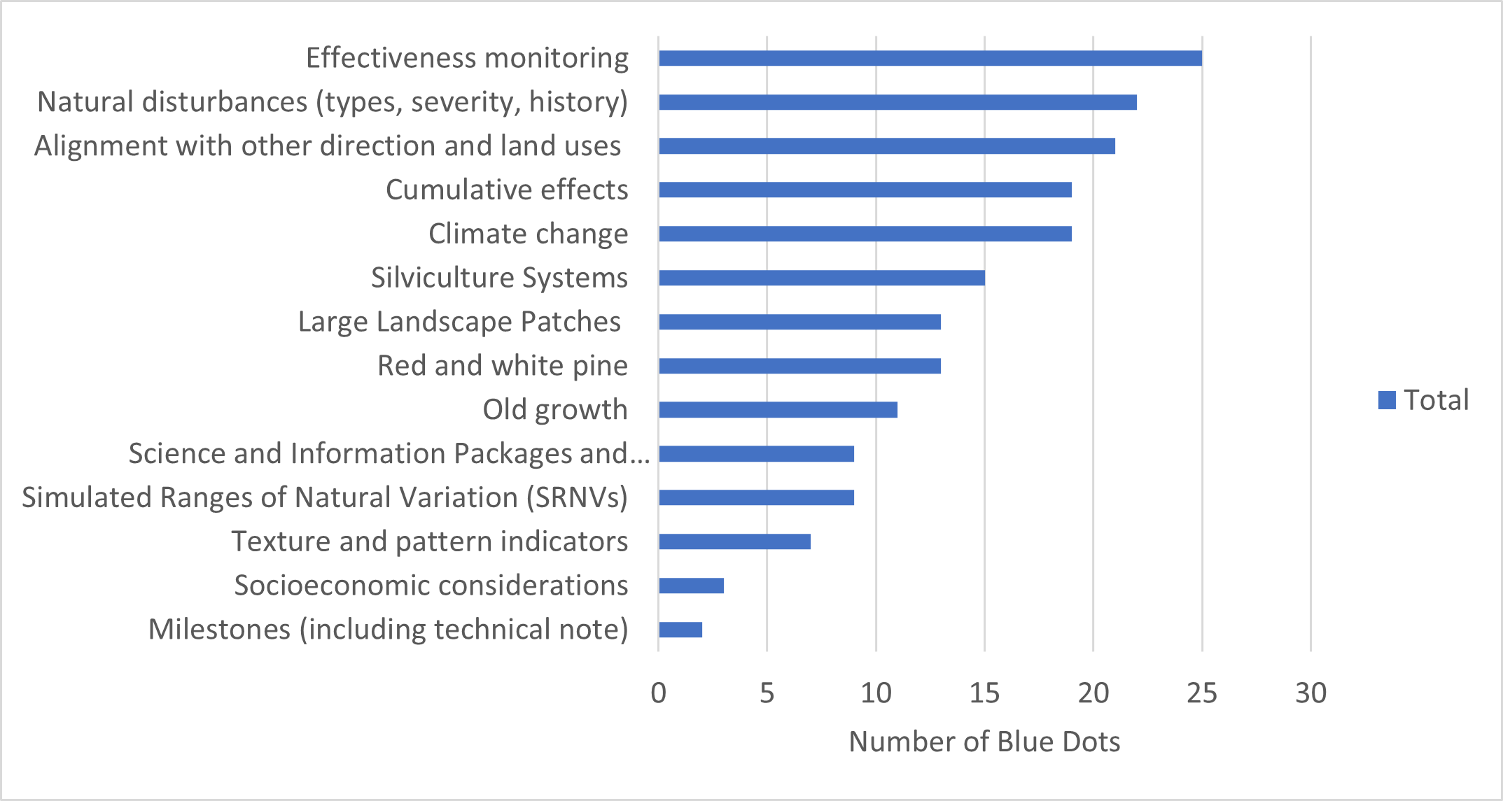
Once the list of topics was agreed upon, participants voted on which topics would be included in this breakout group activity. They were provided six blue stickers as votes to identify the topic(s) that were their highest priority to discuss. Participants could place as many stickers on a given topic as they wanted. Figure 2.6 shows a summary of the votes for activity 3, where the BLG was the focus of the workshop. Effectiveness monitoring, cumulative effects, climate change, SRNVs, and caribou received the most votes across all workshops. Figure 2.7 shows the same summary for the GLSL LG, and effectiveness monitoring, natural disturbance, other land uses, cumulative effects, and climate change received the most votes.
The topics with the most votes were transferred to chart paper, and participants were asked to identify the biggest challenges and opportunities to address each topic on sticky notes.
After participants contributed their individual thoughts to each topic, groups were formed for each of the selected topics. Participants could join a topic of their choosing, and some participants opted to circulate between topics. The groups were tasked with summarizing the key points from the sticky notes and identifying how the challenges and opportunities could be addressed, including what changes to landscape guide direction might be required. Summaries from each group were presented to all workshop participants. Details from these discussions are captured in section 2.2.2, section 2.5 and Appendix B.
2.2.1.4 Activity 4: Cue Cards
The goal of the Cue Card activity was to receive any additional feedback from participants about the landscape guides and the review process for the guides (e.g., information session, workshops, survey). Participation was optional, and everyone was invited to write their comments on a cue card and place it in a feedback box, or to provide additional comments by email or phone. The feedback could be provided at any time during or after the workshops. The intent of this activity was to allow an additional avenue for feedback, especially for some people who may not be comfortable speaking in large groups. Comments through this activity were generally only received at the larger workshops.
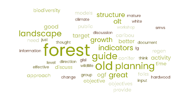
The comments varied from general appreciation of the workshop structure and opportunities for participation, to detailed suggestions for revisions. Figure 2.8 is a word cloud summary of the comments received on cue cards. The landscape guide indicators, including old growth and other structure indicators were a focus in these comments. A record of all comments from this activity is found in Appendix B.
2.2.2 Summary notes from each workshop
Sections 2.2.2.1-2.2.2.10 provide brief summaries of the discussions and main themes at each workshop. These sections capture discussion items that were part of the workshop agenda item “Reflection from the day”. Many of these points echo what was heard in the workshop activities, and new considerations were also discussed.
2.2.2.1 Kenora Workshop
The workshop in Kenora occurred on January 30, 2024. Nine of the 12 individuals that registered participated. Participants included two forest industry representatives, a representative from a First Nation organization, and MNR staff.
Themes of discussion focused on:
- simulated ranges of natural variation (SRNVs),
- non-stand replacing disturbances,
- red and white pine forests,
- guide effectiveness monitoring,
- spatial modelling,
- a need to maintain/update tools and supporting documentation for landscape guide application, and
- potential delays in guide revision if the caribou direction is revised. There was a suggestion to create a separate guide for caribou related direction.
2.2.2.2 Dryden Workshop
The workshop in Dryden occurred on February 1, 2024. Sixteen of the 23 individuals that registered participated. Participants included forest industry representatives, a First Nation community representative, and MNR staff. Participants appreciated the opportunity to meet in-person and enjoyed the structure of the workshop.
Themes of discussion focused on:
- importance of effectiveness monitoring,
- cumulative effects (including disturbance assessments that support caribou related planning),
- opportunities to improve caribou-related direction,
- how direction around large landscape patches is applied in planning,
- challenges in achieving red and white pine objectives,
- landscape-level consideration for roads,
- suggestions to move away from species-specific related direction where possible (e.g., caribou, moose), and
- need for plain language communication materials about the landscape guide.
2.2.2.3 Thunder Bay Workshop
The workshop in Thunder Bay occurred on February 6, 2024. Forty-four of the 52 individuals that registered participated. Participants included forest industry representatives, an Indigenous community representative, stakeholders, government staff, and academic representatives. The feedback from this workshop was constructive overall and focused on landscape guide implementation.
Themes of discussion focused on:
a need to maintain/increase flexibility in the guide,
a need for training to increase the consistency of application of the guide,
the need for plain language communication materials,
a need for inclusion of Indigenous knowledge,
improvements that could be made to the caribou related direction,
importance of effectiveness monitoring and the need to communicate efforts,
a need to consider climate change and associated challenges (including need to test multiple hypotheses),
consideration of multiple scales when applying direction in the guide,
importance of maintaining/improving tools to support implementation of the landscape guide,
general concern that forest management guides in general (including the landscape guide) are too prescriptive and limit the ability for practitioners to respond to social demands, and
potential delays to forest management planning due to potential revisions to the landscape guides, and
concern about the timelines for the Boreal SRNV project results will delay forest management planning.
2.2.2.4 Timmins Workshop
The Timmins workshop occurred on February 13, 2024. Forty-two of the 44 individuals that registered participated. Participants included forest industry representatives, First Nation community and organization representatives, MNR staff, and stakeholders. Participants provided constructive feedback on landscape guide implementation and identified opportunities for improvement.
Themes of discussion focused on:
the need to co-apply Indigenous knowledge,
engaging meaningfully with Indigenous peoples,
a need for communication of concepts in the guide in plain language,
importance of effectiveness monitoring and a need to communicate updates on effectiveness monitoring efforts (specific comments on moose emphasis areas),
training/communication to support consistent implementation of landscape guide direction (including “discretionary” direction),
technical discussions about landscape guide indicators and content,
a request for the Spanish forest to be moved from the Great Lakes-St. Lawrence landscape guide regions to the Boreal,
a discussion about the value of amalgamating the landscape guide,
concern for the lack of Indigenous involvement in the guide development process,
concerns about the lack of effectiveness monitoring, and
a discussion about timelines for potential guide revisions and concerns about potential delays to forest management planning.
2.2.2.5 Hearst Workshop
The Hearst workshop occurred on February 15, 2024. Eleven of the 14 individuals that registered participated. Participants included forest industry representatives and MNR district and regional staff.
Themes of discussion focused on:
how to consider climate change in the landscape guide and forest management (including reference to an MNR initiative with the Hearst Forest “Climate Change Panel” ~10 years ago),
applicability of some caribou-related direction to the Claybelt area,
applicability of red and white pine direction,
increasing flexibility in the landscape guide to respond to local considerations and Indigenous community desired forest and benefits,
technical discussions about SRNVs and landscape guide structure (e.g., suggestion to remove caribou direction from the guide),
importance of tools and communication to support implementation of the landscape guide,
importance of effectiveness monitoring (including communication),
concern about the consistency in implementation of caribou-related direction in the landscape guide,
implementation of direction in the landscape guide that leads to identification of objectives/indicators that are not achievable and implications for the annual reports.
2.2.2.6 Peterborough Workshop
The Peterborough workshop occurred on February 22, 2024. Twenty-one of the 26 individuals that registered participated. Participants included forest industry representatives and MNR staff.
Themes of discussion focused on:
mixed opinions on reducing and simplifying direction in the landscape guide (some suggested redundancies, suggestion to remove old growth indicator and old growth policy reference),
suggestions to include more direction in certain parts of the landscape guide (i.e., large landscape patches),
potential improvements to the landscape guide by better incorporating considerations of different silviculture systems,
importance of effectiveness monitoring,
suggestion to remove FMP reporting requirements for the landscape guide indicators,
challenges in applying the landscape guide with other direction (e.g., amount of private land in the south, fine filter, broader land use planning),
technical discussion on landscape guide application (e.g., milestone technical note, indicator assessments),
importance of considering climate change in all forest management guides, and
concerns about the number of large landscape patches (e.g., moose emphasis areas, deer emphasis areas) applied by forest management planning teams during implementation of the landscape guide and stand and site guide.
2.2.2.7 Virtual Workshop
The virtual workshop was hosted online on February 28, 2024, using MS Teams. Eighteen of the 23 individuals that registered participated. Participants included forest industry representatives, an Indigenous community representative and MNR staff.
Some participants had to leave for portions of the day, which resulted in some adaptations to the group activities.
Themes of discussion focused on:
importance of maintaining and reporting on landscape guide indicators (especially landscape classes) to assess long-term trends,
importance of communicating landscape guide concepts (e.g., support consistent implementation and public support)
maintaining/improving supporting tools and documents,
opportunity for Indigenous knowledge and local knowledge to be co-applied with landscape guide concepts,
conflicting views on the need to revise landscape guide forest units (specifically for Great Lakes-St. Lawrence area),
inclusion of landscape scale direction for roads (e.g., road density indicator),
opportunity to clarify direction for old growth desirable levels and include considerations for different silviculture systems,
opportunity for future improvements with spatial models and LiDAR metrics,
inclusion of considerations for climate change and cumulative effects in the landscape guide,
concerns that policy changes may compromise the ability to report on indicators and track long-term changes, and
concern that tight timelines mean there are limited options for revisions to be ready for the next round of planning.
2.2.2.8 Sault Ste Marie Workshop
The Sault Ste Marie workshop occurred on March 5, 2024. Twenty of the 25 individuals that registered participated. Participants included an Indigenous community representative, forest industry representatives and MNR staff. The majority of the discussions at this workshop were solution oriented.
Themes of discussion focused on:
opportunity to take advantage of technology improvements (e.g., LiDAR, spatial models),
importance of maintaining/modernizing tools/models to support consistent and efficient implementation of landscape guides,
need for training to increase consistency of application of the guide,
need for plain language communication materials,
socioeconomic factors limiting the ability to achieve landscape guide objectives (e.g., markets, social values),
technical discussions about landscape guide indicators and content (e.g., clarification of t-stage, relevance of red and white pine indicator),
consideration of multiple scales, cumulative effects and climate change when applying direction in the guide,
importance of effectiveness monitoring (including reporting) and prioritization of associated work,
support for the structure of the guide,
good timing for revisions to occur alongside other policy changes, and
suggested change in language to increase flexibility in the guide (e.g., remove specific reference to Ontario’s Landscape Tool).
2.2.2.9 North Bay Workshop
The North Bay workshop occurred on March 7, 2024. Twenty-four of the 28 individuals that registered participated. Participants included Indigenous community representatives, forest industry representatives, consultants with experience in spatial modelling, and MNR staff.
Themes of discussion focused on:
opportunities of technology advancements and spatial models (e.g., other metrics of forest structure),
importance of maintaining/modernizing Ontario’s Landscape Tool and training/communication to support consistent implementation of landscape guides,
technical discussions about landscape guide indicators and content (e.g., order of application of the indicators),
need for and importance of including Indigenous knowledge in revisions,
consideration of multiple scales and cumulative effects when applying direction in the guide,
importance of effectiveness monitoring (including silviculture),
potential for fine filter direction to conflict with landscape guide coarse filter direction,
discussions about potential improvements to old growth indicator,
suggestion to include more text about climate change and how to assess risk,
suggestion for more guidance around strategic landscape maps and roads,
support for the structure of the landscape guides,
suggestions to remove caribou direction from the boreal landscape guide,
recommendation that feedback should be sought while planning teams are actively planning,
divided opinions on the benefits of amalgamating the landscape guides,
recommendation to move the Spanish forest from the Great Lakes-St. Lawrence landscape guide regions to the Boreal, and
concerns about the timelines for potential revisions to support the next round of forest management planning, and suggestions to keep revisions tightly scoped.
2.2.2.10 Bracebridge Workshop
The Bracebridge workshop occurred on March 12, 2024. Ten of the 12 individuals that registered participated. Participants included forest industry representatives, consultants with experience in spatial modelling, and MNR staff.
Themes of discussion focused on:
the landscape guide not being a major driver in forest management planning in the GLSL south,
application of fine filter direction and protection of other values is a bigger driver in the south,
limitation of the ability of management actions to influence the achievement of landscape guide indicators (e.g., due to amount of private land, silviculture systems used),
general appreciation for the landscape guide structure but suggested “tweaks”, including that large landscape patches should not be applied in the GLSL South,
importance of considering climate change an acknowledgement that climate change considerations expand beyond the landscape guide,
importance of effectiveness monitoring (including consistency of reporting indicators across plans) and avoiding a process of “planning for the sake of planning”,
importance of communication of training messages and plain language messaging for the public,
importance of maintaining documents and tools supporting the implementation of the landscape guide,
technical discussions about the landscape guide (e.g., potential changes to red and white pine direction, wind disturbance in the SRNV model),
suggestion to consider managed forest and protected areas separately in indicator assessments,
concerns expressed about the fine filter direction applied from other guides (e.g., stand and site guide) impacting the application of coarse filter direction in the landscape guide, and
concern about the effort to apply some direction (e.g., large landscape patches) may not be worth the time/resources if not effective (i.e., importance of effectiveness monitoring).
2.3 Survey
The online survey was developed in MS Forms and was provided to participants of the information sessions and workshops during the landscape guide reviews. Participants could complete the survey between January 25th-March 29th, 2024. This survey was designed with targeted questions to inform the review of the landscape guides, and to complement the structure of the workshops. Some questions used the term “evidence”, and respondents were encouraged to consider all forms of evidence and knowledge (e.g., Indigenous knowledge, western science) in their responses.
The survey had nine sections, listed below. Some questions were conditional on the answers to preceding questions (e.g., questions with “yes” or “no” answers), where additional questions would appear. There was a total of 77 questions, but not all questions were required to be answered. Section 1 was the only section with required fields, and respondents could skip any of the remaining questions or sections. Section 8 was only applicable to those who wanted to comment on the caribou habitat direction in the BLG. The following is a list of sections in the survey:
Participant information and experience
General guide questions
Guide implementation (mandatory direction)
Milestones
Science supporting the landscape guide
Effectiveness and effects
Climate change
Caribou habitat (if applicable)
Concluding comments
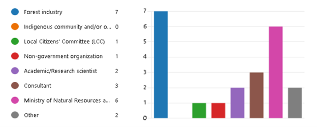
The survey had 16 respondents who represented forest industry, local citizen committees (LCC), stakeholders, and government staff (Figure 2.9). Many of these individuals had experience as planning team members applying the landscape guide(s), and they included plan authors, foresters, biologists, analysts, and LCC members (Figure 2.10). Most respondents were not involved in the development of the landscape guide, and most respondents provided feedback in context of the Boreal Landscape Guide.
The number of respondents was lower than expected, and this limited the ability to summarize the results quantitatively in a meaningful way. The low response rate was likely due to a number of reasons, including the ability to participate in the other feedback opportunities (e.g., workshops, meetings, written comments), time constraints due to competing priorities, and length of the survey.
The following section (2.3.1) provides an overview of some results from the survey. More detailed results are found in Appendix C.
2.3.1 Overview of survey results
Respondents were asked to rate how easy it was to follow direction in the landscape guide on a scale of one to ten. The average response was 6.38, with 12/16 (75%) participants responding ≥7. However, 81% of respondents indicated that there was some direction in the landscape guide that was challenging to implement, with comments generally relating to challenges with achieving indicator desirable levels and with interpretation of guide direction. Approximately half of the respondents also indicated that the landscape guide direction conflicts with other sources of direction, indicating that the fine filter direction in the landscape guides and Stand and Site Guide sometimes compromise the ability to appropriately apply the coarse filter direction in the guide.
When asked if there were gaps with the landscape guide direction about half of respondents indicated they were not sure, and the majority of other respondents said there were gaps. For those who indicated there were gaps, most comments were generally related to updates that could be made to science supporting the implementation of the landscape guide. For example, improvements to the Simulated Ranges of Natural Variation (SRNVs) were suggested, including the addition of updated inventory information and insect outbreaks.
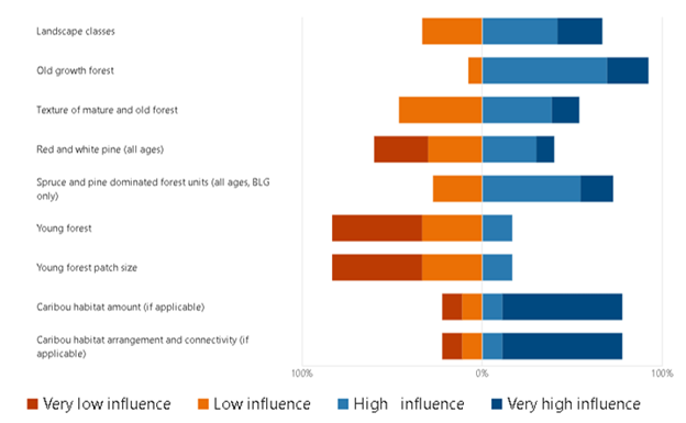
Respondents were asked, in their experience, what the relative influence of each landscape guide indicator group was on the strategic direction of a forest management plan. The results generally indicated that the area-based indicators for older seral stages had a greater influence on the long-term management direction in plans (Figure 2.11). When asked if they were able to achieve milestones, respondents had varying responses, with the majority saying “not sure”. Generally, during the workshop and in the survey, there was some confusion about the difference between SRNVs and milestones. The SRNVs are used to inform desired levels of the landscape guide indicators, while milestones inform targets for when those desired levels are to be achieved. Continued communication about this concept in the landscape guide is important to the success of the guide’s implementation.
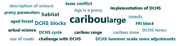
There were six respondents that answered questions related to caribou habitat direction in the BLG. Comments were generally related to experience with applying a Dynamic Caribou Habitat Schedule (DCHS) and making changes to existing DCHS designs implemented in a previous plan. Some comments indicated that there were challenges in achieving some landscape guide indicators when applying a DCHS, and additional resources to support this process would be helpful including ways to co-apply Indigenous knowledge. Figure 2.12 is a word cloud summarizing some of the key terms used in the responses.
Respondents were also asked if they believed the BLG and the GLSL LG should be amalgamated into one landscape guide. Similar to the feedback heard during the workshops, the majority of respondents said “maybe” (Figure 2.13). The consensus was that an amalgamation of the landscape guides would likely improve consistency in direction, but may not benefit planning teams implementing the guide. However, amalgamating the guides was perceived to have a risk of creating delays in revising guide direction, given the expanded scope.

When asked if the landscape guides should be revised, approximately half of respondents said “yes” and half of the respondents said “not sure”. The comments associated with these responses identified some specific suggestions for revisions (e.g., change which landscape class the PWUSC forest unit contributes to). More generally, the comments indicated support for the current structure of the landscape guides and most concerns from implementing the guide can be addressed through updates to science and information (e.g., SRNVs) and application of the milestone technical note. One respondent stated “These are good guides - they provide clear direction that both practitioners and regulators can stand behind - not something that all provinces have.”
Many respondents believed that there is insufficient time before the next round of forest management planning to make any major changes to the landscape guides, and the guides can be applied “as is”. However, there are some relatively minor changes that would be helpful to support the next round of management plans. There seemed to be a consensus from the survey and workshops that an addendum or minor revision to the landscape guides should be considered in the short-term. The scope of these revisions would be to update the guide to align with current policies and legislation and add clarity to some of the direction in the guide (e.g., alignment of forest units and landscape classes). The overall intent would be to support consistent application of the guides. One of the more significant suggested short-term revisions was to move the Spanish Forest from the Great Lakes-St. Lawrence Landscape Guide Regions to the Boreal. This suggestion was made during the workshop and in the survey and is further discussed in section 3.1.
Respondents also acknowledged a need to address items that apply to more than just the landscape guides, including climate change and Indigenous knowledge. Currently, section 2.3.1 of the landscape guides acknowledges how direction in the landscape guide is intended to address and enable management to adapt to emerging climate change science and information. Indigenous knowledge is not explicitly acknowledged in the landscape guides. Survey responses suggested establishing a task team or advisory team to explore these topics and how they can become a larger part of the landscape guide and associated implementation.
Other responses advocated for more support in implementing the landscape guides. Specifically, more training to help with the consistency of interpreting direction, more public communication materials, and updates to the science, information and tools used in planning. A specific comment was made requesting more resources and direction to support implementation red and white pine indicator (i.e., identify desirable levels). Respondents showed support for the milestone technical report and supported other direction following a similar format to provide planning teams with more flexibility when applying direction to local situations. Respondents also advocated for more effort to monitor the effectiveness of the landscape guides in emulating natural forest composition, structure, and patterns, and communication of these efforts.
More details from survey responses are provided in Appendix C. There are additional ways the results can be summarized which may be of interest, including a sentiment analysis related to key terms (e.g., caribou, climate change, science). These analyses may be explored in the future if time permits and can be appended to the review or included in the science packages.
2.4 Additional Feedback
There were several written responses provided outside of the workshops and surveys, as well as separate meetings. Feedback continued to be accepted until the end of June 2024. In general, these meetings echoed much of the feedback heard through the workshops and survey.
The comments indicated overall support for the landscape guides. There were specific recommendations for the timeline of potential landscape guide revisions to align with timelines in the Caribou Conservation Agreement (Palmer et al. 2024). After these comments were received, the Science Assessment Report (ECCC 2024) was released but did not provide conclusive recommendations for specific revisions to the landscape guide. There were also recommendations to enhance the focus of the landscape guide on ecological integrity by improving or including explicit considerations for old growth forest, high-integrity forests, forest degradation, carbon sequestration and co-benefits, cumulative disturbance, caribou, and wolverine (Palmer et al. 2024). These were recommended to be considered in the context of several federal commitments and initiatives (e.g., 2030 National Biodiversity Strategy) and the United Nations Declaration on the Rights of Indigenous Peoples (UNDRIP). There was also support expressed to continue current efforts in the Boreal SRNV Project to co-apply Indigenous knowledge to better understand natural forest conditions.
MNR regional planning biologists provided a consolidated list of comments for the landscape guide reviews, which is documented in Appendix D. A large portion of the comments related to caribou habitat, including suggestions for the direction to improve consistent application of a Dynamic Caribou Habitat Schedule and associated spatial assessments (e.g., time slice, texture assessment). The comments indicated concerns in determining “sufficient supply” of calving and nursery area habitat to inform application of the guide direction. There were also specific comments on areas to improve the applicability of direction to the Claybelt area in the Northeast Region and to provide clearer direction for caribou habitat in the Lake Superior Coast Range and Discontinuous Distribution.
More generally, the comments suggested improvements were needed to spatial assessments, particularly in the context of spatial models. In some plans, it was noted that the spatial assessments were not part of an iterative process to assess achievement of the indicators, which was partly a result of software limitations. There were also suggestions to address road-related objectives, and clarify direction of landscape guide indicators (e.g., when grouping of forest units are required).
Other comments echoed the feedback from the workshop and survey, and generally advocated for changes that would improve consistency in landscape guide implementation. There were recommendations for improving training and communication, and updating and maintaining the science, information and tools that support the landscape guides. There were also suggestions for formatting changes to the landscape guides and clarification. Finally, these comments indicated support for focusing efforts on effectiveness monitoring and transparent communication of these efforts.
2.5 Overall Themes
Overall, the feedback from the engagement sessions indicated that the landscape guides could be improved by simplifying the language in the guide. Participants generally expressed a reluctance to remove any direction from the guide without a clear understanding of the effectiveness and effects.
The feedback received from practitioners, First Nation peoples, Métis peoples and stakeholders are summarized in this section under five main themes:
- Importance of communication (training, plain language)
- Inclusion of Indigenous Knowledge
- Concerns about Effectiveness Monitoring
- Climate Change, Cumulative Effects, Caribou
- Simulated Ranges of Natural Variation (SRNV)
There was also specific feedback about suggested changes which may not be captured by these themes but were summarized in the previous sections and in the Appendices. These sections of the report are intended to be useful references when considering and drafting revisions to the landscape guide(s).
2.5.1 Communication
There was a clear message that many challenges in implementing the landscape guides can likely be overcome through improved communication. This includes the creation and delivery of consistent training materials for forest management planning teams, communication across planning teams, and the need for plain language communication materials for the public.
In the last round of planning, many planning teams experienced challenges in explaining how species-specific wildlife habitat was now captured in the landscape guide indicators. Previously, there were several species-specific guides that required planning teams to have species-specific indicators, which was relatively easy for a public audience to understand. The landscape guide uses landscape classes, which are groupings of forest types by age class that are intended to be meaningful to wildlife. These classes were derived from a cluster analysis of species-specific habitat classifications (Holloway et al. 2004). The development and delivery of materials to explain the landscape classes and broader forest management approach would be helpful to build understanding of the landscape guides within planning teams and the broader public.
Similarly, there were several comments during these reviews that suggested certain desired forest and benefits (e.g., values and objectives identified by First Nation communities or Métis communities) could not be included in the strategic direction of a forest management plan because they would conflict with requirements of the landscape guide. In some cases, practitioners may not be aware of the role professional expertise and local knowledge has in context-specific application of the guide. Some practitioners were also not aware of the guideline where rationale and revised milestones is required if the achievement of a non-landscape guide objectives are favoured over the achievement of a landscape guide milestone. This flexibility in guide direction enables planning teams to “supply the technological means to…sociological ends” (Behan 1966). Improved training messages and learning from the considerations and reflections described by Robinson et al (2024) may help forest management planning teams address these challenges in the future.
Evidence of a lack of understanding about landscape guide direction was also highlighted by statements during the engagement sessions that suggested the pattern indicators could be measured directly in spatial forest estate models. The forest estate modelling software being used in forest management plans from 2024 onward will be spatial, but they are not able to directly measure or apply constraints for these indictors in a model. There have not been any proxy measurements used for texture indicators, and young forest patch size proxies are not directly comparable to desirable levels for these indicators that were calculated using the Landscape Scripting Language. Enhanced training materials and simplified messaging can bridge this knowledge gap identified by practitioners.
2.5.2 Indigenous Knowledge
Indigenous knowledge is a term that is noticeably absent in the landscape guides. The feedback received from the landscape guide reviews was very supportive of including Indigenous knowledge in the landscape guides and co-applying western science and Indigenous knowledge. There was also acknowledgement that it would take time to achieve this respectfully and in a meaningful way. In the spirit of reconciliation, this work should not be rushed, should not be delayed, and should be approached in a good way (Reid et al. 2024). This work requires long-term thinking, but short term revisions may also be considered to promote the inclusion of Indigenous knowledge during application and implementation of the landscape guides.
A collaborative approach with First Nation communities and organizations and Métis communities and organizations should be pursued, and this comes with the challenge of trying to meaningfully engage with everyone at once. Suggestions for collaboration are included in Robinson et al. (2024), including: building relationships through proactive and creative opportunities for engagement outside formal planning processes, having conversations about forest management at larger spatial scales, and collaborating on higher level strategic opportunities (e.g., national biodiversity objectives). Nudds and Villard (2011) suggest focusing on how both western science and Indigenous knowledge value learning could promote collaboration by encouraging everyone to learn together. Each knowledge system has ways of storing, transmitting, revising and responding to knowledge gained through experience, which constantly evolves.
Examples of co-applying Indigenous knowledge and the landscape guide would be a valuable resource for planning teams. Currently, the Boreal SRNV Project Team established a Pre-industrial Condition Task Team that is focusing on Indigenous Knowledge to understand what a pre-industrial condition means, with a focus on forest landscape patterns. This knowledge is intended to help validate a simulation model that estimates what a natural range of forest conditions in the boreal forest may look like, and provide an example of landscape guide application as a resource to forest management planning teams.
One of the first steps taken by the task team was to proposed options for pursuing this work, and the team identified a set of guiding principles to inform their work: respect, relationships, reciprocity, collaboration and transparency. Meetings have begun with lands and resources representatives and knowledge holders from Apitipi Anicinapek Nation, Beaverhouse First Nation, Matachewan First Nation, and Mattagami First Nation. Details on how this work will proceed are still being discussed but is expected to include field- and desktop-based meetings. Results of this work are expected to help inform implementation of the landscape guides and is currently planned to be documented in the science and information packages.
More generally, this work in the Boreal SRNV Project may be considered an example of “democratizing science” that supports the landscape guides. The term “science” in this sense can be thought of as knowledge systems, including western science, Indigenous knowledge systems, and local knowledge systems (Salomon et al, 2018, Nudds 2025). The basic principle of this concept is to make the process for coproducing knowledge accessible and participatory, as demonstrated by Salomon et al. (2018) in their research on resiliency of social-ecological systems. The Boreal SRNV Project Team is an interdisciplinary team that represents and brings perspectives from diverse areas of expertise in a participatory process.
2.5.3 Effectiveness Monitoring
Effectiveness monitoring was the most popular topic in activity 3 for almost every workshop. As part of the adaptive management approach used in Ontario’s forest policy and management frameworks, monitoring programs and scientific investigations have been established to inform key uncertainties associated with guide direction. Guide effectiveness monitoring may include programs and projects internal or external to the MNR and follows the general direction for addressing critical uncertainty described in the Effectiveness Monitoring of Forest Management Guides Strategic Direction (Rempel et al 2011).
Feedback from the workshops and additional engagement highlighted that there is a lack of awareness of current effectiveness monitoring efforts as it relates to direction in the landscape guides. This resulted in a recommendation to improve communication about these efforts in a timely and transparent way. Participants were interested in understanding if the landscape guide direction is “working”, which is encouraging and seems to indicate support for the direction in the guides. Of particular interest was the uncertainty around the coarse and fine filter approach providing habitat for multiple wildlife species. Participants expressed a desire to understand wildlife population responses to management actions. Most workshops included a discussion about the challenges in directly assessing this key uncertainty, as the landscape guide direction applies to large spatial and temporal scales. Additionally, the landscape guides have only been applied for 10-15 years, and therefore a response of ecological communities and wildlife populations at the landscape would not necessarily be expected to have occurred. Study areas where guide direction has been applied as intended and that spans an appropriate spatial and temporal scale would need to be identified, as demonstrated by Rempel et al (2014).
During the workshops, there were discussions about current efforts to inform landscape guide direction. Forest Management Policy Section is currently working with the Science and Research Branch to validate the landscape classes using empirical data, primarily using data collected as part of the Multiple Species Inventory and Monitoring (MSIM) program and Ontario Wildlife Monitoring Network (OWMN). More information about this work is provided in section 3.2.
2.5.4 Climate Change, Cumulative Effects, Caribou
Climate change, cumulative effects, and caribou are complex topics that are acknowledged to require a significant amount of time and additional engagement prior to proposing revisions. These topics also span beyond the scope of just the landscape guides. Therefore, these topics are expected to be addressed through revisions to the landscape guides in the longer-term.
Climate change was also a significant topic in the 2015 GLSL LG review. At that time, it was concluded that the objective to maintain and enhance biodiversity is appropriate given the uncertainty associated with climate change. The following points were provided as supporting rationale:
- emulation of natural disturbance patterns to enhance and conserve ecosystem complexity and biodiversity is a reasonable strategy that enables forests to accommodate and respond to change
- ecosystem resilience, the capacity to absorb and recover from disturbance, is higher in more diverse forests
- ecosystem stability, temporal and spatial variability in function, is higher in more diverse forests
- diverse, resilient forests are better able to sustainably provide ecological goods and services upon which society depends
- traditional management approaches have transformed, fragmented, simplified, and homogenized forests that are less resilient to disturbance.
Comments received during the engagement sessions of the review strongly suggested incorporating climate change in the landscape guide, but most were not sure how this could be done. The terms “healthy”, “diverse”, “adaptable” and “socially acceptable” were identified as desirable goals for new direction. Many participants suggested assisted migration of drought-tolerant species northward and diversifying forests would create a forest that is more resilient to climate change. The Ontario Seed Transfer Policy includes flexibility for forest managers to consider future climate when making seed transfer decisions.
Some participants suggested the adaptive management process could address climate change concerns as new science and information becomes available. The regular review process for forest management guides and the requirement to develop forest management plans every 10 years allows this to occur at a reasonable interval given the temporal scale of climate change. Others suggested that current direction in the landscape guide has sufficient flexibility to address climate change concerns, and it might make more sense to provide specific direction outside of the landscape guide. Many participants also suggested the SRNV should account for climate change. Relationships between natural, historical and future ranges of variation (Safford et al 2012) were discussed in the 2015 GLSL landscape guide review. The current Boreal SRNV Project has identified work to explore how climate change can be considered in the modelling exercise, and any potential results are intended to be made available in the science and information packages.
There was proposed direction drafted and documented in the 2015 GLSL LG review report. The general consensus from presenting this direction at workshops in the GLSL review and to the PFTC was that it should not be included as a guide revision. The main reason for this conclusion was the low likelihood that planning teams would apply the direction due to the amount of supporting evidence required.
Cumulative effects of multiple activities and land uses on the landscape can be challenging to manage. In the GLSL, participants expressed concern about the cumulative impact of Area of Concern prescriptions (developed in applications of the Stand and Site Guide) on the achievement of landscape guide objectives. This part of the province already has a relatively fragmented landscape based on ownership. Other concerns about cumulative effects include access roads established for forest harvesting purposes subsequently being used for other purposes. The direction regarding large landscape patches and their collective development of a strategic landscape map is flexible and can be used to partially address concerns about cumulative effects. However, with multiple activities and land uses, this topic may be more fully addressed outside the context of just the landscape guides.
As noted in other parts of section 2, the caribou-related direction in the BLG was identified as a high priority for revisions. Several participants suggested that a disturbance indicator be included in the BLG. In general, updates to caribou-related direction were suggested to be consistent with results from the Canada-Ontario Caribou Conservation Agreement. However, there was also an acknowledgement that much of the on-going work under the caribou conservation agreement would not be available until at least 2027. The results of this work and other ongoing research are expected to provide directly relevant science and information that could inform potential revisions to the BLG. Wilson et al (2021, 2025b) have recently explored the cause and effect relationship of caribou habitat management actions and population responses, as assumed by caribou recovery planning. Factors other than habitat disturbance may be limiting the effectiveness of habitat restoration in recovering caribou populations (Wilson 2025b), which provides important context for Ontario’s forest management and policy. The development of a Knowledge Plan under Conservation Measure 1.4, including a comprehensive literature review, would be a valuable information source when considering revisions to the BLG.
Related to Conservation Measure 4.1 (Evidence-based Approaches), a Science Assessment Report was released in April 2024. The report recommended a “commitment to a transparent process for evaluating and incorporating new information in existing regulatory frameworks, in a timely manner.” This recommendation aligns with the review requirement identified in the FOSM, and the adaptive approach used in Ontario’s forest policy framework.
2.5.5 Simulated Ranges of Natural Variation (SRNV)
Engagement on the review of a forest management guide often identifies potential improvements that could be made to the science supporting implementation of guide. Many comments received during this review period suggested improving the SRNV estimates in the science and information packages and Ontario’s Landscape Tool (OLT). Prior to the landscape guide reviews commencing, it was decided to re-estimate the boreal SRNVs using available updated science and information. This decision was made based on feedback heard during the implementation of the BLG in forest management planning. Four key issues were identified with the boreal SRNVs:
Accuracy of estimates of red and white pine
Changes to upland/lowland ecosites in the inventories
Edge effect of the Manitoba border and lack of inventory data for provincial parks
Ability to achieve all ages conifer desirable level informed by the SRNV
A report on these issues and options to address these concerns can be found in Appendix F. This report identifies potential new science, information and tools that could be used to re-estimate the boreal SRNVs and approximate timelines and steps to follow. This report provided a starting point for the Boreal SRNV Project, driven by practitioner experience.
Feedback about the SRNVs from the landscape guide review workshops was shared with the Boreal SRNV Project Team for consideration while improving the current model. This feedback helped to prioritize the incorporation of spruce budworm into the model, which had not been included previously. Workshop participants also expressed a desire to be engaged in the project prior to results being released.
In the GLSL, participants were interested in whether there were any plans to update the SRNVs released in 2017. There was a suggestion to improve the inventory attribute (i.e., VERT) used to identify the overstory or understory as the managed canopy. Generally, age is a poor measure of structure in the GLSL in comparison to the boreal. Use of LiDAR information in the future may help to address these inventory-related concerns.